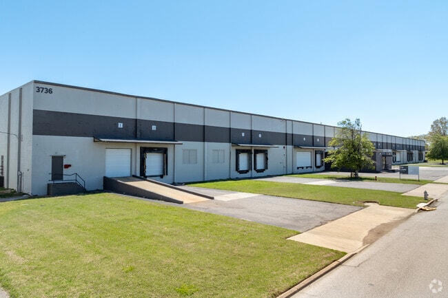
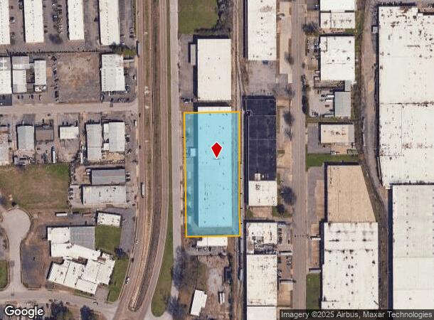
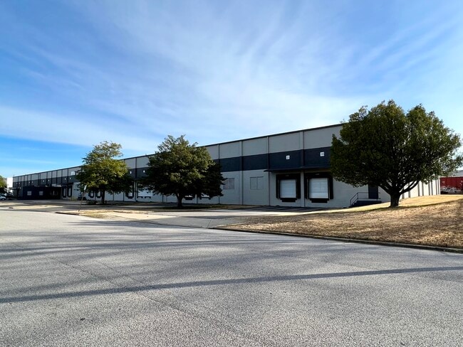
Property Record
3736 New Getwell Rd, Memphis, TN 38118
Current Lease Availabilities
NEARBY LISTINGS FOR SALE OR LEASE
Property Detail
3736 New Getwell Rd
Memphis, TN-MS-AR
Airport Industrial Park Sec B
07-3035-0-0050
LOT PT 66 ES NEW GETWELL RD
Warehouse
Shelby
X
Tennessee
47157C0445F
67-71
2024
3.28 AC
2025
Southeast
022600
Memphis
81,625 SF
DEMOGRAPHICS near 3736 New Getwell Rd
1 Mile
3 Mile
5 Mile
2024 Total Population
5,638
53,045
180,676
2029 Population
5,740
53,090
180,643
Pop Growth 2024-2029
+ 1.81%
+ 0.08%
(0.02%)
Average Age
31
34
36
2024 Total Households
2,083
18,343
70,102
HH Growth 2024-2029
+ 1.87%
+ 0.19%
(0.12%)
Median Household Inc
$39,363
$38,913
$41,505
Avg Household Size
2.70
2.80
2.50
2024 Avg HH Vehicles
1.00
2.00
2.00
Median Home Value
$93,804
$81,687
$120,108
Median Year Built
1975
1970
1969
Nearby Places
- Restaurants
- Banks
- Shops
- Fitness
- Groceries
PUBLIC TRANSPORTATION
AIRPORT
Memphis International
DRIVE
WALK
Distance
Memphis International
7 min
4.0 mi
Freight Ports
Port of Shreveport
DRIVE
WALK
Distance
Port of Shreveport
413 min
378.6 mi
Nearby Properties
Address
Land Use
TOTAL SIZE
Lot Size
Zoning
Address
Land Use
TOTAL SIZE
Lot Size
Zoning
969,150 SF
64.49 AC
EMP
Address
Land Use
TOTAL SIZE
Lot Size
Zoning
717,155 SF
83.34 AC
CA
Address
Land Use
TOTAL SIZE
Lot Size
Zoning
838,318 SF
39.56 AC
I-L
Address
Land Use
TOTAL SIZE
Lot Size
Zoning
189,536 SF
49.14 AC
CMU-2
Address
Land Use
TOTAL SIZE
Lot Size
Zoning
237,911 SF
21.38 AC
EMP
Address
Land Use
TOTAL SIZE
Lot Size
Zoning
118,116 SF
60.70 AC
CMU-2
Address
Land Use
TOTAL SIZE
Lot Size
Zoning
571,642 SF
23.56 AC
EMP
Address
Land Use
TOTAL SIZE
Lot Size
Zoning
1,292,907 SF
83.13 AC
IH
Address
Land Use
TOTAL SIZE
Lot Size
Zoning
1,034,433 SF
53.32 AC
EMP
Address
Land Use
TOTAL SIZE
Lot Size
Zoning
861,322 SF
72.92 AC
CA
Address
Land Use
TOTAL SIZE
Lot Size
Zoning
739,205 SF
31.51 AC
AG
Address
Land Use
TOTAL SIZE
Lot Size
Zoning
654,400 SF
46.39 AC
EMP
Address
Land Use
TOTAL SIZE
Lot Size
Zoning
714,692 SF
30.88 AC
EMP
Address
Land Use
TOTAL SIZE
Lot Size
Zoning
2,847.82 AC
EMP
Address
Land Use
TOTAL SIZE
Lot Size
Zoning
38,488 SF
5.68 AC
CMU-1
Address
Land Use
TOTAL SIZE
Lot Size
Zoning
188,458 SF
29.19 AC
RU-3
Address
Land Use
TOTAL SIZE
Lot Size
Zoning
605,539 SF
28.59 AC
RU-1
Address
Land Use
TOTAL SIZE
Lot Size
Zoning
618,133 SF
37.58 AC
EMP
Address
Land Use
TOTAL SIZE
Lot Size
Zoning
508,104 SF
36.83 AC
EMP
Address
Land Use
TOTAL SIZE
Lot Size
Zoning
585,535 SF
31.96 AC
EMP
Address
Land Use
TOTAL SIZE
Lot Size
Zoning
457,681 SF
21.02 AC
EMP
Address
Land Use
TOTAL SIZE
Lot Size
Zoning
1,137,460 SF
62.54 AC
IH
Address
Land Use
TOTAL SIZE
Lot Size
Zoning
81,454 SF
EMP
Address
Land Use
TOTAL SIZE
Lot Size
Zoning
58.21 AC
R-6
Address
Land Use
TOTAL SIZE
Lot Size
Zoning
532,073 SF
20.99 AC
EMP
Address
Land Use
TOTAL SIZE
Lot Size
Zoning
509,111 SF
EMP
Address
Land Use
TOTAL SIZE
Lot Size
Zoning
421,769 SF
21.59 AC
CA
Address
Land Use
TOTAL SIZE
Lot Size
Zoning
300,702 SF
14.40 AC
RU-3
Address
Land Use
TOTAL SIZE
Lot Size
Zoning
342,605 SF
82.99 AC
CA
Address
Land Use
TOTAL SIZE
Lot Size
Zoning
411,635 SF
18.35 AC
EMP
The World's #1 Commercial Real Estate Marketplace
Connect with us
© 2025 CoStar Group
The information above has been obtained from sources believed reliable. While we do not doubt its accuracy we have not verified it and make no guarantee, warranty or representation about it. It is your responsibility to independently confirm its accuracy and completeness. Any projections, opinions, assumptions, or estimates used are for example only and do not represent the current or future performance of the property. The value of this transaction to you depends on tax and other factors which should be evaluated by your tax, financial, and legal advisors. You and your advisors should conduct a careful, independent investigation of the property to determine to your satisfaction the suitability of the property for your needs.